Geographical Concepts and Challenges
Interactive Video
•
Geography
•
9th - 10th Grade
•
Practice Problem
•
Hard

Jackson Turner
FREE Resource
Read more
10 questions
Show all answers
1.
MULTIPLE CHOICE QUESTION
30 sec • 1 pt
What is the main challenge when trying to visualize the longest straight line across the Earth's surface?
The Earth's surface is covered in water.
The Earth's surface is too small.
Maps are two-dimensional.
The Earth's surface is flat.
2.
MULTIPLE CHOICE QUESTION
30 sec • 1 pt
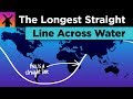
Which two countries are connected by a straight line across water, as mentioned in the video?
Norway and Greenland
Spain and Venezuela
Italy and Brazil
Italy and Venezuela
3.
MULTIPLE CHOICE QUESTION
30 sec • 1 pt
What is a 'great circle' in the context of Earth's geometry?
An imaginary circle that divides the Earth into two equal halves.
A circle that only exists in the ocean.
A circle that is drawn on a flat map.
A circle that covers the entire Earth.
4.
MULTIPLE CHOICE QUESTION
30 sec • 1 pt
What technique did the researchers use to find the longest straight line across water?
Trial and error
Branch and bound
Direct measurement
Satellite imaging
5.
MULTIPLE CHOICE QUESTION
30 sec • 1 pt
Where does the longest straight line path on land start and end?
India to China
Australia to Canada
Pakistan to Russia
Brazil to South Africa
6.
MULTIPLE CHOICE QUESTION
30 sec • 1 pt
What is a significant challenge when crossing the Drake Passage?
Calm waters
Strong winds and currents
Dense fog
High temperatures
7.
MULTIPLE CHOICE QUESTION
30 sec • 1 pt
What is Point Nemo known for?
Being the deepest point in the ocean
Being the furthest point from any land
Being the closest point to the equator
Being the highest point in the ocean
Access all questions and much more by creating a free account
Create resources
Host any resource
Get auto-graded reports
Continue with Google

Continue with Email
Continue with Classlink
Continue with Clever
or continue with
Microsoft
%20(1).png)
Apple
Others
Already have an account?
