Understanding Maps and Their Uses
Interactive Video
•
Geography
•
6th - 7th Grade
•
Practice Problem
•
Hard

Patricia Brown
FREE Resource
Read more
10 questions
Show all answers
1.
MULTIPLE CHOICE QUESTION
30 sec • 1 pt
Who was the geographer known for his influence on map-making until the 16th century?
Ptolemy
Copernicus
Galileo
Newton
2.
MULTIPLE CHOICE QUESTION
30 sec • 1 pt
Which type of map would you use to find the boundaries of countries?
Physical map
Topographic map
Political map
Thematic map
3.
MULTIPLE CHOICE QUESTION
30 sec • 1 pt
What type of map would show the distribution of rainfall in a region?
Political map
Physical map
Thematic map
Climate map
4.
MULTIPLE CHOICE QUESTION
30 sec • 1 pt
What is a small-scale map best used for?
Navigating a small town
Displaying a single building
Detailed city planning
Showing large areas with limited detail
5.
MULTIPLE CHOICE QUESTION
30 sec • 1 pt
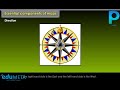
How is direction typically indicated on a map?
By a legend
By a grid
By a scale bar
By a compass rose
6.
MULTIPLE CHOICE QUESTION
30 sec • 1 pt
What is the purpose of conventional symbols on a map?
To display the map's title
To represent various features like roads and buildings
To show elevation
To indicate the map's scale
7.
MULTIPLE CHOICE QUESTION
30 sec • 1 pt
Which of the following is NOT an essential component of a map?
Direction
Symbols
Distance
Altitude
Access all questions and much more by creating a free account
Create resources
Host any resource
Get auto-graded reports
Continue with Google

Continue with Email
Continue with Classlink
Continue with Clever
or continue with
Microsoft
%20(1).png)
Apple
Others
Already have an account?
