Bathymetry and Ocean Mapping Concepts
Interactive Video
•
Geography
•
9th - 10th Grade
•
Practice Problem
•
Hard

Patricia Brown
FREE Resource
Read more
10 questions
Show all answers
1.
MULTIPLE CHOICE QUESTION
30 sec • 1 pt
Who was part of the bathymetry sub-team for the 2018 fall XPrize competition?
Maddy Nelson and Albert Riley
Maddy Nelson and David Sandwell
Brendan Chang and Bryan Bergamini
Albert Riley and David Sandwell
2.
MULTIPLE CHOICE QUESTION
30 sec • 1 pt
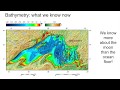
What is bathymetry?
The study of ocean and lake floors
The study of weather patterns
The study of mountain ranges
The study of atmospheric pressure
3.
MULTIPLE CHOICE QUESTION
30 sec • 1 pt
How are bathymetric maps typically represented?
With topographic lines only
With satellite images
Using the rainbow color spectrum and rings
Using black and white gradients
4.
MULTIPLE CHOICE QUESTION
30 sec • 1 pt
Why is bathymetry important for safe travel?
It is used for satellite communication
It helps in mapping air routes
It helps in predicting weather conditions
It provides data for nautical charts
5.
MULTIPLE CHOICE QUESTION
30 sec • 1 pt
How does bathymetry contribute to understanding climate change?
By tracking animal migration
By measuring atmospheric CO2 levels
By determining changes in sea level
By predicting rainfall patterns
6.
MULTIPLE CHOICE QUESTION
30 sec • 1 pt
What was the resolution of the ocean floor map created in 2014?
Around 5 kilometers
Around 1 kilometer
Around 20 kilometers
Around 10 kilometers
7.
MULTIPLE CHOICE QUESTION
30 sec • 1 pt
Which celestial bodies have more detailed maps than the ocean floor?
Jupiter and Saturn
Mars, the Moon, and Venus
The Sun and Mercury
Pluto and Neptune
Access all questions and much more by creating a free account
Create resources
Host any resource
Get auto-graded reports
Continue with Google

Continue with Email
Continue with Classlink
Continue with Clever
or continue with
Microsoft
%20(1).png)
Apple
Others
Already have an account?
