Understanding Maps and Their Features
Interactive Video
•
Geography
•
6th - 7th Grade
•
Practice Problem
•
Hard

Patricia Brown
FREE Resource
Read more
10 questions
Show all answers
1.
MULTIPLE CHOICE QUESTION
30 sec • 1 pt
What is the main focus of the lesson introduced by Mr. CB?
Exploring different types of maps
Learning about historical events
Studying cultural traditions
Understanding political boundaries
2.
MULTIPLE CHOICE QUESTION
30 sec • 1 pt
Which question should you consider to understand what a map is sharing?
What is the age of the map?
What is the size of the map?
What is the title of the map?
What is the scale of the map?
3.
MULTIPLE CHOICE QUESTION
30 sec • 1 pt
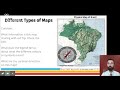
What does a physical map primarily show?
Climate zones
Natural resources
Political boundaries
Physical geography
4.
MULTIPLE CHOICE QUESTION
30 sec • 1 pt
On a physical map, what do blue lines typically represent?
Mountains
Rivers
Deserts
Forests
5.
MULTIPLE CHOICE QUESTION
30 sec • 1 pt
What is an intermediate direction between north and east?
Northwest
Southwest
Southeast
Northeast
6.
MULTIPLE CHOICE QUESTION
30 sec • 1 pt
What type of map uses symbols to represent resources?
Physical map
Natural resource map
Climate map
Political map
7.
MULTIPLE CHOICE QUESTION
30 sec • 1 pt
What does the legend on a natural resource map indicate?
The types of resources
The scale of the map
The age of the map
The political boundaries
Access all questions and much more by creating a free account
Create resources
Host any resource
Get auto-graded reports
Continue with Google

Continue with Email
Continue with Classlink
Continue with Clever
or continue with
Microsoft
%20(1).png)
Apple
Others
Already have an account?
