Calculating Mount Everest's Height
Interactive Video
•
Mathematics, Science, Geography
•
9th - 12th Grade
•
Practice Problem
•
Hard

Patricia Brown
FREE Resource
Read more
10 questions
Show all answers
1.
MULTIPLE CHOICE QUESTION
30 sec • 1 pt
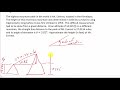
What was the primary method used to determine the height of Mount Everest in 1856?
Climbing to the peak
Using trigonometry
Satellite imaging
Aerial photography
2.
MULTIPLE CHOICE QUESTION
30 sec • 1 pt
What was the altitude of the mountain where the surveyors were positioned?
14,545 feet
27,013.4 feet
5,280 feet
8,848 feet
3.
MULTIPLE CHOICE QUESTION
30 sec • 1 pt
What is the angle of elevation from the surveyors' position to the peak of Mount Everest?
5.82 degrees
7.5 degrees
15 degrees
10 degrees
4.
MULTIPLE CHOICE QUESTION
30 sec • 1 pt
Which trigonometric function is used to calculate the height of Mount Everest in this problem?
Sine
Tangent
Secant
Cosine
5.
MULTIPLE CHOICE QUESTION
30 sec • 1 pt
What is the straight-line distance from the surveyors to the peak of Mount Everest?
5.82 miles
8,848 miles
27.0134 miles
14,545 miles
6.
MULTIPLE CHOICE QUESTION
30 sec • 1 pt
How many feet are there in one mile?
5,280 feet
6,000 feet
1,000 feet
3,280 feet
7.
MULTIPLE CHOICE QUESTION
30 sec • 1 pt
What is the calculated height of Mount Everest in miles before conversion?
2.739 miles
5.280 miles
14.545 miles
27.013 miles
Access all questions and much more by creating a free account
Create resources
Host any resource
Get auto-graded reports
Continue with Google

Continue with Email
Continue with Classlink
Continue with Clever
or continue with
Microsoft
%20(1).png)
Apple
Others
Already have an account?
