Types of Maps and Their Uses
Interactive Video
•
Geography
•
9th - 10th Grade
•
Practice Problem
•
Hard

Patricia Brown
FREE Resource
Read more
10 questions
Show all answers
1.
MULTIPLE CHOICE QUESTION
30 sec • 1 pt
What is the primary purpose of a reference map?
To show political boundaries
To illustrate historical events
To communicate spatial information
To display thematic data
2.
MULTIPLE CHOICE QUESTION
30 sec • 1 pt
Which type of map would you use to find the absolute location of a place?
Thematic map
Isoline map
Reference map
Cartogram
3.
MULTIPLE CHOICE QUESTION
30 sec • 1 pt
What distinguishes a thematic map from a reference map?
It displays roads and highways
It communicates spatial aspects
It shows political boundaries
It uses symbols of different sizes
4.
MULTIPLE CHOICE QUESTION
30 sec • 1 pt
What does a chloropleth map use to represent data?
Lines connecting equal points
Dots of the same size
Distorted country sizes
Different colors or shades
5.
MULTIPLE CHOICE QUESTION
30 sec • 1 pt
In a dot density map, what does each dot represent?
A specific quantity of a spatial characteristic
An elevation level
A different size of a variable
A political boundary
6.
MULTIPLE CHOICE QUESTION
30 sec • 1 pt
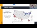
How do graduated or proportional symbol maps differ from dot density maps?
They display roads and highways
They use lines to connect points
They use symbols of different sizes
They show political boundaries
7.
MULTIPLE CHOICE QUESTION
30 sec • 1 pt
What is a cartogram used for?
To connect equal points of value
To distort area based on a variable
To display roads and highways
To show elevation
Access all questions and much more by creating a free account
Create resources
Host any resource
Get auto-graded reports
Continue with Google

Continue with Email
Continue with Classlink
Continue with Clever
or continue with
Microsoft
%20(1).png)
Apple
Others
Already have an account?
