
What determines a watershed? Topography introduction
Presentation
•
Science
•
6th - 8th Grade
•
Medium
•
NGSS
MS-ESS2-3
Standards-aligned

LESLEY BABE
Used 19+ times
FREE Resource
9 Slides • 16 Questions
1
2

3
4

5
Multiple Choice
6
Multiple Choice
7
Multiple Choice

What is the elevation of point B?
8

9

10
Multiple Choice
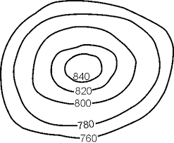
Determine the contour interval:
11
Multiple Choice

What is the highest elevation on this map?
12
Multiple Choice
13

14
Multiple Choice
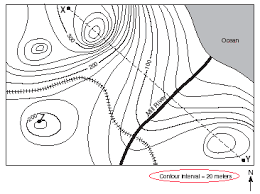
How many peaks are on the map? (hill tops)
15

16
Multiple Choice

What is the thick line indicating the elevation on a topographic map called?
17

18
Multiple Choice
19
Multiple Choice
20
Multiple Choice

Which side of Holland Hill is the steepest?
21
Multiple Choice

Which side is steeper?
22
Multiple Choice
23
Multiple Choice

Which topographic map matches formation C?
24
Multiple Choice

Match the topographic map to its profile.
25
Multiple Choice
Show answer
Auto Play
Slide 1 / 25
SLIDE
