Watersheds of Pennsylvania
Interactive Video
•
Science, Geography, Other
•
6th - 8th Grade
•
Practice Problem
•
Hard

Patricia Brown
FREE Resource
Read more
10 questions
Show all answers
1.
MULTIPLE CHOICE QUESTION
30 sec • 1 pt
Who defined a watershed as a bounded hydrologic system where all living things are linked by their common water course?
Pennsylvania Envirothon
Blair County Conservation District
US Department of Environmental Protection
John Wesley Powell
2.
MULTIPLE CHOICE QUESTION
30 sec • 1 pt
According to the US Department of Environmental Protection, what is a watershed?
A region where all water drains into different places
An area of land where all water drains into the same place
A type of water body
A place where water is stored
3.
MULTIPLE CHOICE QUESTION
30 sec • 1 pt
How many watersheds are there in the continental United States?
2110
2267
1500
3000
4.
MULTIPLE CHOICE QUESTION
30 sec • 1 pt
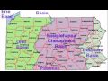
Which of the following is NOT one of the main watersheds in Pennsylvania?
Ohio River Basin
Delaware River Basin
Lake Erie Watershed
Mississippi River Basin
5.
MULTIPLE CHOICE QUESTION
30 sec • 1 pt
What watershed is central Pennsylvania a part of?
Genesee Watershed
Potomac River Basin
Juniata Watershed
Ohio River Basin
6.
MULTIPLE CHOICE QUESTION
30 sec • 1 pt
Which two watersheds is Blair County divided into?
Ohio River Basin and Lake Erie Watershed
Little Juniata and Frankstown Branch
Susquehanna River Basin and Delaware River Basin
Potomac River Basin and Genesee Watershed
7.
MULTIPLE CHOICE QUESTION
30 sec • 1 pt
What geographical feature often defines the lines that divide watersheds?
Valleys
Mountaintop ridges
Lakes
Rivers
Access all questions and much more by creating a free account
Create resources
Host any resource
Get auto-graded reports
Continue with Google

Continue with Email
Continue with Classlink
Continue with Clever
or continue with
Microsoft
%20(1).png)
Apple
Others
Already have an account?
