Scales of Analysis in Geography
Interactive Video
•
Geography, Social Studies, History
•
9th - 12th Grade
•
Practice Problem
•
Hard

Patricia Brown
Used 1+ times
FREE Resource
Read more
10 questions
Show all answers
1.
MULTIPLE CHOICE QUESTION
30 sec • 1 pt
What is the primary focus of the lecture on scales of analysis?
To analyze the impact of climate change
To define and explain scales of analysis used by geographers
To explore the cultural differences in various regions
To discuss the history of geography
2.
MULTIPLE CHOICE QUESTION
30 sec • 1 pt
How does the lecture differentiate between map scale and scale of analysis?
Map scale and scale of analysis are the same
Map scale is used for historical data, while scale of analysis is for current data
Map scale refers to the size of the map, while scale of analysis refers to the level of data analysis
Map scale is about the number of maps, while scale of analysis is about the number of data points
3.
MULTIPLE CHOICE QUESTION
30 sec • 1 pt
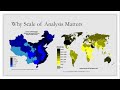
What does the lecture suggest about voting trends when comparing different scales?
Voting trends are irrelevant to scales of analysis
Voting trends are consistent across all scales
Different scales reveal different voting patterns and trends
Voting trends are only visible at the national scale
4.
MULTIPLE CHOICE QUESTION
30 sec • 1 pt
What is the significance of the 'purple areas' mentioned in the lecture?
They are regions with a mix of political affiliations
They are regions where voting trends are unpredictable
They are areas with consistent voting patterns
They represent areas with no voting data
5.
MULTIPLE CHOICE QUESTION
30 sec • 1 pt
Which scale of analysis is useful for examining globalization?
Local
Regional
National
Global
6.
MULTIPLE CHOICE QUESTION
30 sec • 1 pt
How does the lecture describe the regional scale of analysis?
As a scale that only considers national borders
As a scale that focuses on global economic trends
As a scale that looks at areas unified by a common trait or purpose
As a scale that examines individual cities
7.
MULTIPLE CHOICE QUESTION
30 sec • 1 pt
What example is used to illustrate the national scale of analysis?
Local cuisine
Cultural festivals
Voting trends
Global warming
Access all questions and much more by creating a free account
Create resources
Host any resource
Get auto-graded reports
Continue with Google

Continue with Email
Continue with Classlink
Continue with Clever
or continue with
Microsoft
%20(1).png)
Apple
Others
Already have an account?
Popular Resources on Wayground

7 questions
History of Valentine's Day
Interactive video
•
4th Grade
15 questions
Fractions on a Number Line
Quiz
•
3rd Grade
20 questions
Equivalent Fractions
Quiz
•
3rd Grade
25 questions
Multiplication Facts
Quiz
•
5th Grade
22 questions
fractions
Quiz
•
3rd Grade
15 questions
Valentine's Day Trivia
Quiz
•
3rd Grade
20 questions
Main Idea and Details
Quiz
•
5th Grade
20 questions
Context Clues
Quiz
•
6th Grade
Discover more resources for Geography
35 questions
Unit 5 Lesson 5 & 6 Quiz - Religions & Religious Conflict
Quiz
•
9th Grade
29 questions
Europe, SW Asia and N Africa Review
Quiz
•
10th Grade
20 questions
Mardi Gras History
Quiz
•
6th Grade - University
15 questions
Population Pyramid
Quiz
•
9th Grade
15 questions
Eastern Europe Map Quiz '25
Quiz
•
9th Grade
12 questions
Unit 3: Population Pyramid Practice
Quiz
•
9th Grade
46 questions
AP Human Geography Unit 4 Review
Quiz
•
9th - 12th Grade