Mapping the World: The Art and Science of Cartography
Interactive Video
•
Geography
•
4th - 5th Grade
•
Practice Problem
•
Hard

Patricia Brown
FREE Resource
Read more
8 questions
Show all answers
1.
MULTIPLE CHOICE QUESTION
30 sec • 1 pt
What is the primary role of a cartographer?
To navigate using stars
To explore new lands
To create and update maps
To teach geography
2.
MULTIPLE CHOICE QUESTION
30 sec • 1 pt
What does a scale drawing on a map represent?
The actual size of the earth
The relative size of map features to real-world features
The distance between two points
The height of mountains
3.
MULTIPLE CHOICE QUESTION
30 sec • 1 pt
Why is it challenging to create a two-dimensional map of the earth?
Because the earth is flat
Because the earth is round
Because maps are always inaccurate
Because continents are constantly moving
4.
MULTIPLE CHOICE QUESTION
30 sec • 1 pt
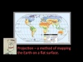
What is a projection in cartography?
A way to draw mountains
A tool to find directions
A technique to map the earth on a flat surface
A method to measure distances
5.
MULTIPLE CHOICE QUESTION
30 sec • 1 pt
Which tools do cartographers use to make projections?
Maps and globes
Rulers and protractors
Aerial photographs, satellite images, and ground surveys
Telescopes and compasses
6.
MULTIPLE CHOICE QUESTION
30 sec • 1 pt
What is the purpose of a compass rose on a map?
To display directions like north, south, east, and west
To measure distances
To indicate the map's legend
To show the scale of the map
7.
MULTIPLE CHOICE QUESTION
30 sec • 1 pt
What does the key or legend on a map explain?
The directions on the map
The history of the map
The symbols and shading used on the map
The scale of the map
Access all questions and much more by creating a free account
Create resources
Host any resource
Get auto-graded reports
Continue with Google

Continue with Email
Continue with Microsoft
or continue with

%20(1).png)
Apple
Others
Already have an account?
