Understanding Maps: Thematic, Political, and Physical
Interactive Video
•
Geography, Social Studies
•
5th - 8th Grade
•
Practice Problem
•
Easy

Amelia Wright
Used 1+ times
FREE Resource
Read more
9 questions
Show all answers
1.
MULTIPLE CHOICE QUESTION
30 sec • 1 pt
What are the three types of maps discussed in the video?
Topographical, Climatic, and Demographic
Economic, Social, and Environmental
Geographical, Historical, and Cultural
Thematic, Political, and Physical
2.
MULTIPLE CHOICE QUESTION
30 sec • 1 pt
Which of the following is an example of a thematic map?
Topographic map
Weather map
City tourist map
World map
3.
MULTIPLE CHOICE QUESTION
30 sec • 1 pt
What kind of information do thematic maps primarily display?
Historical events
Data related to a specific area
Land features
Borders of countries
4.
MULTIPLE CHOICE QUESTION
30 sec • 1 pt
What do political maps primarily show?
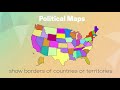
Climate zones
Borders of countries or territories
Population density
Natural resources
5.
MULTIPLE CHOICE QUESTION
30 sec • 1 pt
Which features are typically shown on physical maps?
Land features like mountains and rivers
Economic activities
Political boundaries
Cultural landmarks
6.
MULTIPLE CHOICE QUESTION
30 sec • 1 pt
What is not typically included in the essential elements of a map?
Weather forecast
Title
Scale
Legend
7.
MULTIPLE CHOICE QUESTION
30 sec • 1 pt
Which element of a map helps you understand the symbols used?
Legend
Direction
Title
Scale
Access all questions and much more by creating a free account
Create resources
Host any resource
Get auto-graded reports
Continue with Google

Continue with Email
Continue with Classlink
Continue with Clever
or continue with
Microsoft
%20(1).png)
Apple
Others
Already have an account?
Similar Resources on Wayground

6 questions
These Countries Are The Least Populated In The World! | KLT
Interactive video
•
KG - 9th Grade
6 questions
I WONDER - How Old Are Icebergs?
Interactive video
•
KG - 6th Grade
6 questions
Faraón
Interactive video
•
6th - 9th Grade
6 questions
Covid-19 R number falls below 1 for the first time since July
Interactive video
•
6th - 8th Grade
6 questions
How to Make a Pythagoras Cup
Interactive video
•
KG - 9th Grade
Popular Resources on Wayground
7 questions
History of Valentine's Day
Interactive video
•
4th Grade
15 questions
Fractions on a Number Line
Quiz
•
3rd Grade
20 questions
Equivalent Fractions
Quiz
•
3rd Grade
25 questions
Multiplication Facts
Quiz
•
5th Grade
22 questions
fractions
Quiz
•
3rd Grade
15 questions
Valentine's Day Trivia
Quiz
•
3rd Grade
20 questions
Main Idea and Details
Quiz
•
5th Grade
20 questions
Context Clues
Quiz
•
6th Grade
Discover more resources for Geography
21 questions
Continents and Oceans
Quiz
•
6th Grade
10 questions
Seasons and Earth's Tilt
Quiz
•
7th Grade
12 questions
Russia, Central Asia, & the Caucasus
Quiz
•
6th Grade
20 questions
Mardi Gras History
Quiz
•
6th Grade - University
16 questions
Southern and Eastern Asia Government Basics
Quiz
•
7th Grade
21 questions
Plate Tectonics and Earth's Structure review quiz
Quiz
•
6th Grade
10 questions
38a, b, c: Voluntary trade in Africa
Quiz
•
7th Grade
10 questions
Understanding Landslides
Interactive video
•
5th - 6th Grade