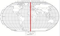
Understanding Absolute Location in Geography
Passage
•
Social Studies
•
9th - 12th Grade
•
Easy
Kristen Whiley
Used 3+ times
FREE Resource
Enhance your content in a minute
18 questions
Show all answers
1.
MULTIPLE CHOICE QUESTION
30 sec • 1 pt
What does the relative location of a place tell you?
the longitude and latitude of a place
where a place is compared to another place
the map projection being used to show a place
which symbol shows a place on a map
2.
MULTIPLE CHOICE QUESTION
45 sec • 1 pt
What is the primary method for determining absolute location in geography?
Using latitude and longitude
Using street addresses
Using landmarks
Using postal codes
3.
MULTIPLE CHOICE QUESTION
45 sec • 1 pt
How do latitude lines run on the Earth's surface?
Parallel to the Equator
From the North Pole to the South Pole
Diagonally across continents
In a circular pattern
4.
MULTIPLE CHOICE QUESTION
45 sec • 1 pt
What technology uses a network of satellites to provide location data?
Global Positioning System (GPS)
Radio towers
Weather balloons
Underwater cables
5.
MULTIPLE CHOICE QUESTION
45 sec • 1 pt
What does the Geographic Coordinate System use to describe locations on Earth?
Numerical coordinates
Color codes
Alphabetical codes
Symbolic representations
6.
MULTIPLE CHOICE QUESTION
45 sec • 1 pt
Why is the Geographic Coordinate System important for cartography and navigation?
It ensures consistent and accurate location data
It provides colorful maps
It simplifies language translation
It reduces the need for physical maps
7.
MATCH QUESTION
1 min • 1 pt

Match the following
Human Interaction
A place relative to another place defines
Relative Location
Humans' involvement with the earth and other humans is
Cardinal Directions
This location never changes
Toponym
North, south, East and West are
Absolute Location
The name given to places on earth
Create a free account and access millions of resources
Create resources
Host any resource
Get auto-graded reports

Continue with Google

Continue with Email

Continue with Classlink

Continue with Clever
or continue with

Microsoft
%20(1).png)
Apple
Others
By signing up, you agree to our Terms of Service & Privacy Policy
Already have an account?
Similar Resources on Wayground

20 questions
Physical Resources
Quiz
•
11th - 12th Grade

14 questions
General knowledge quiz
Quiz
•
5th Grade - Professio...

17 questions
African American Resistance Review
Quiz
•
11th Grade

20 questions
Ekonomiks Quiz 1
Quiz
•
9th Grade

15 questions
Matariki
Quiz
•
6th - 12th Grade

20 questions
Poverty
Quiz
•
9th - 10th Grade

16 questions
Thinkers Beliefs and Buildings 1
Quiz
•
10th Grade - Professi...

20 questions
Manufacturing Industries
Quiz
•
10th Grade
Popular Resources on Wayground

10 questions
Honoring the Significance of Veterans Day
Interactive video
•
6th - 10th Grade

10 questions
Exploring Veterans Day: Facts and Celebrations for Kids
Interactive video
•
6th - 10th Grade

19 questions
Veterans Day
Quiz
•
5th Grade

25 questions
Multiplication Facts
Quiz
•
5th Grade

15 questions
Circuits, Light Energy, and Forces
Quiz
•
5th Grade

6 questions
FOREST Self-Discipline
Lesson
•
1st - 5th Grade

7 questions
Veteran's Day
Interactive video
•
3rd Grade

20 questions
Weekly Prefix check #2
Quiz
•
4th - 7th Grade
Discover more resources for Social Studies

8 questions
Veterans Day Quiz
Quiz
•
12th Grade

20 questions
Unit 4 EOU Reteach
Quiz
•
10th Grade

24 questions
Benchmark 3 Review F2022
Quiz
•
11th Grade

10 questions
Exploring Economic Systems and Their Impact
Interactive video
•
6th - 10th Grade

16 questions
Unit 4 Quiz: Renaissance and Feudalism
Quiz
•
10th Grade

20 questions
Unit 4.3 Renaissance Quiz
Quiz
•
10th Grade

41 questions
Unit 8 Key Terms
Quiz
•
11th Grade - University

23 questions
Unit 5: Executive Branch
Quiz
•
9th - 12th Grade


