
Physical Geography of Central Africa
Presentation
•
Social Studies
•
6th Grade
•
Practice Problem
•
Medium

Nathan Fowler
Used 7+ times
FREE Resource
13 Slides • 6 Questions
1
No vocabulary
Vocabulary
identify major physical features of Central Africa
describe how humans and the environment affect each other in Central Africa
Goals
Physical Geography of Central Africa
Essential Question: What are the major physical features of Central Africa?
2

Where did the water come from before entering your home?
Water is constantly moving around the environment through evaporation, precipitation, the ground, rivers, lakes, and human-made facilities.
Recall that a tributary is a smaller river that flows into a larger river. Also, recall that a river basin is an area of land that is drained by a river and all of its tributaries. In Pennsylvania, several river basins are the sources of water for homes.
Access to freshwater is essential for humans!
Think about it!
3
Open Ended
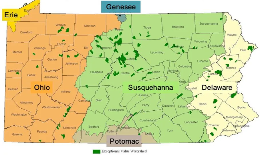
The map shows the major river basins that supply Pennsylvania's water. For example, the Susquehanna River Basin provides Allegheny County with water.
Which river basin supplies the water where you live?
4

Central Africa's northern edge goes to the Adamawa Highlands and the Sahel. You learned about these features when you explored West Africa.
Central Africa's eastern border consists of the Great Rift Valley and Lake Tanganyika, Africa's deepest lake. You learned about these features when you explored East Africa. They are labeled on the physical map.
Introducing Central Africa

5

This political map has labels for the countries of Central Africa. The Democratic Republic of the Congo is Central Africa's largest country and makes up a large portion of the region. Note that the Republic of the Congo and the Democratic Republic of the Congo have similar names, but they are different countries.
Central Africa includes islands in addition to the mainland. Some of these islands are part of the country of Equatorial Guinea. The country called São Tomé and Príncipe consists of two main islands: one called São Tomé (sao toh-MAY), and the other called Príncipe (PRIN-sih-pay).
Central Africa's Political Map
6
Multiple Choice
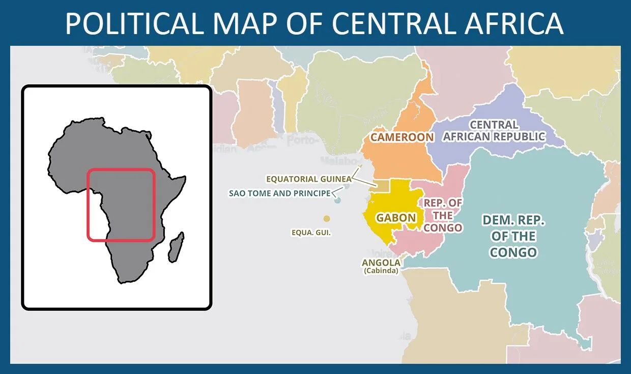
Examine the political map of Central Africa. Which country is located both on islands and on Africa's mainland?
São Tomé and Príncipe
Equatorial Guinea
Democratic Republic of the Congo
7

The main river in Central Africa is the Congo River. The river flows in a counter-clockwise route through the Democratic Republic of the Congo.
Locate the Congo River on the physical map.
Let's watch a video (p. 5 in EDIO).
The Congo River
8
Multiple Select
Where does the Congo River's water come from?
streams that flow down mountains
lakes from the Western Rift Valley (part of the Great Rift Valley)
heavy annual rains
the Atlantic Ocean
9

Much of the Congo River is navigable, or able to be traveled. People use the Congo River to transport goods and passengers. However, some parts are not navigable because of waterfalls and rapids. These obstacles are located near where the river empties into the Atlantic Ocean.
Dams on the Congo River provide hydroelectric power, which is electricity produced using the movement of water. The flowing river pushes a wheel called a turbine that produces electricity.
Using the Congo

10


All of the tributaries that flow into the Congo River make up the Congo Basin.
The Congo Basin
The Congo River and its major tributaries are highlighted on this map. The land that drains into these rivers is the Congo Basin.
Rivers of the Congo Basin
The equator passes through the Congo Basin, so the climate is hot. The Congo Basin contains the humid, rainy Congo Rainforest, the world's second-largest rainforest behind the Amazon Rainforest. The Congo Rainforest is home to a large variety of plants and animals.
The Congo Rainforest
Human activity is threatening the rainforest and its wildlife. People who live near the rainforest use wood as their main source of fuel for cooking. Millions of people cut down trees for this purpose, leading to deforestation. Areas of forest are also cut down to clear land for agriculture. If this activity continues, the Congo Rainforest may disappear.
Deforestation
11

Let's watch a video! (P. 7 of EDIO)
12
Multiple Select
How does human activity threaten the Congo Rainforest and its wildlife?
People cut down trees to use for fuel.
People clear the forest for farming.
People hunt animals for meat.
People overgraze their animals, leading to desertification.
13

Central Africa is rich in natural resources. These resources include copper, diamonds, and petroleum. The Congo River is also source of natural resources, providing freshwater and fish.
The Democratic Republic of the Congo is especially rich in resources. Some scholars estimate that, if you measure a country's wealth by the value of its natural resources, the Democratic Republic of the Congo is the richest country in the world.
However, when measuring people's incomes, the Democratic Republic of the Congo has one of the poorest populations in the world. Wars and corrupt dictatorships have made it difficult for the country to use the natural resources and grow the economy to its potential.
Most of the country's people work as subsistence farmers, growing only enough food to feed their communities.
Natural Resources
14
Multiple Choice
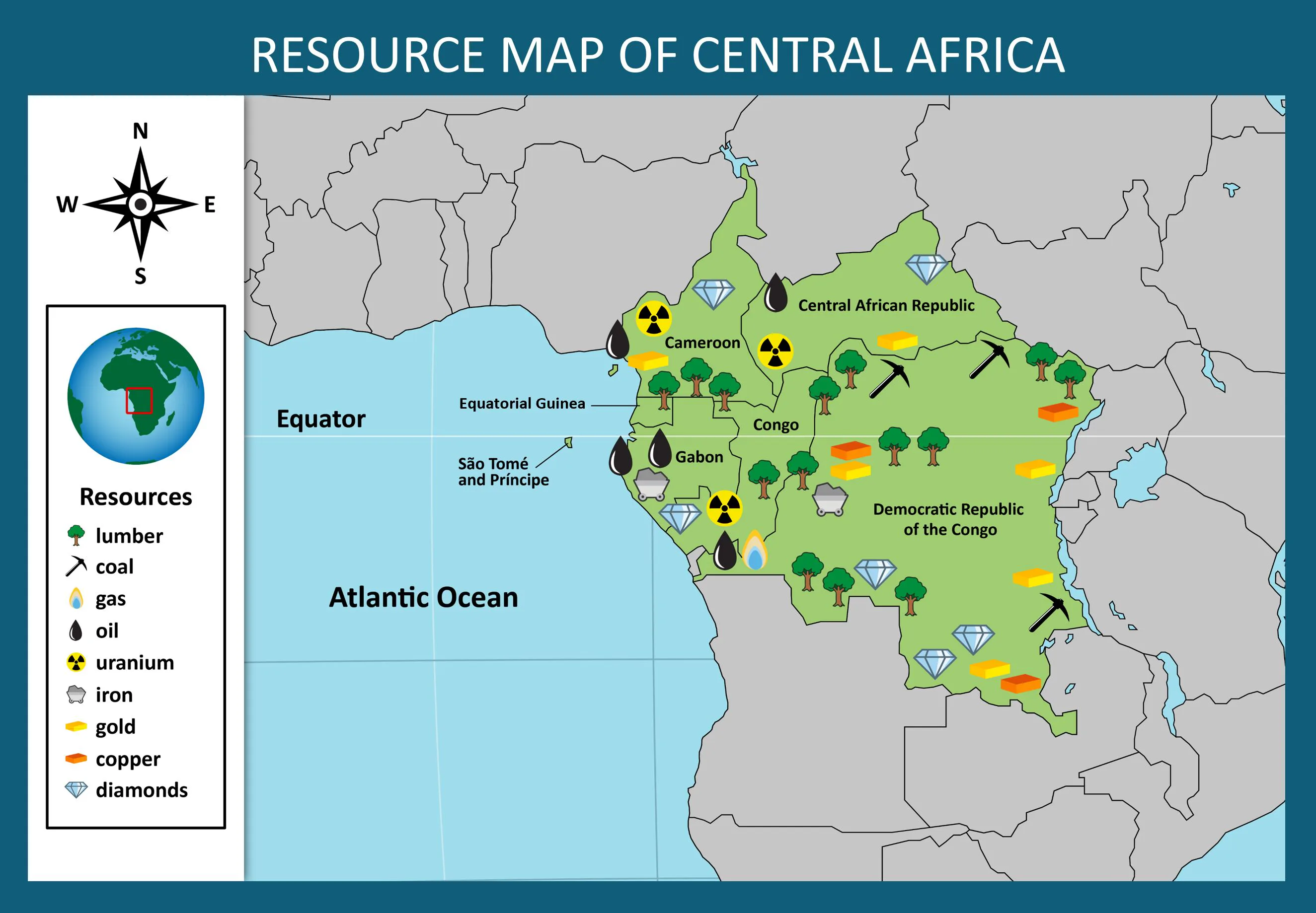
According to the resource map below, which country in Central Africa has the greatest supply of diamonds?
Democratic Republic of the Congo
Central African Republic
Cameroon
15

Lake Chad is located at the northern edge of the Central African country of Cameroon. The lake also borders the West African countries of Nigeria, Niger, and Chad.
Lake Chad is circled on the map shown here.
The lake provides fresh water to people in the countries that border it. People use it for fishing and raising livestock. The lake is also a habitat for animals such as fish, birds, and crocodiles.
It is located in the Sahel, where water is especially valuable due to the semiarid climate.
Lake Chad is Drying Up
16

Lake Chad is shallow, and its size and depth change depending on how much rainfall the area gets. Its average depth ranges from 5 feet to 35 feet.
This shallow lake is drying up. Its water has decreased by over 90 percent since the 1960s. The color-enhanced satellite images below show how much Lake Chad shrank between 1973 and 2021.
One reason Lake Chad is shrinking is because global climate change is leading to drier conditions with less rainfall.
Another reason is that people have built irrigation systems that bring water away from the lake. As the area's population grows, more water is used for purposes such as farming, drinking, and cleaning. A larger population requires more water, and the population is getting too big for the lake to support.
17

Lake Chad is in danger of disappearing by the end of the twenty-first century. If the lake disappears, people and wildlife will lose their supply of fresh water.
A team of eight African countries is trying to find a solution. One idea is to channel water from rivers in the Congo Basin into Lake Chad. This would be a difficult and expensive project, and governments are still figuring out how to carry out the idea.
18
Please complete the exit ticket!
You may submit today's lesson blank.
Reminder
You learned:
The Congo River and the Congo Basin are major features of Central Africa.
Central Africa is rich in natural resources.
Lake Chad is in danger of drying up.
Review
Review and Reminders!
19
Open Ended
Answer one of the questions below.
What is one way the environment in Central Africa affects humans?
What is one way humans affect the environment in Central Africa?
No vocabulary
Vocabulary
identify major physical features of Central Africa
describe how humans and the environment affect each other in Central Africa
Goals
Physical Geography of Central Africa
Essential Question: What are the major physical features of Central Africa?
Show answer
Auto Play
Slide 1 / 19
SLIDE
Similar Resources on Wayground

14 questions
2: PART 2 - Canadian and Australian Economics (SS6E5/SS6E11)
Presentation
•
6th Grade
17 questions
TCI - Investigating the Past CH1
Presentation
•
6th Grade
15 questions
The Phoenicians and The Persian Empire
Presentation
•
6th Grade
13 questions
The Declaration of Independence
Presentation
•
6th Grade
16 questions
Ramses II
Presentation
•
6th Grade
12 questions
PEGS Thrasher 2022
Presentation
•
6th Grade
16 questions
The California Gold Rush
Presentation
•
6th Grade
14 questions
Economic Growth in Canada
Presentation
•
6th Grade
Popular Resources on Wayground
15 questions
Grade 3 Simulation Assessment 1
Quiz
•
3rd Grade
22 questions
HCS Grade 4 Simulation Assessment_1 2526sy
Quiz
•
4th Grade
16 questions
Grade 3 Simulation Assessment 2
Quiz
•
3rd Grade
19 questions
HCS Grade 5 Simulation Assessment_1 2526sy
Quiz
•
5th Grade
17 questions
HCS Grade 4 Simulation Assessment_2 2526sy
Quiz
•
4th Grade
20 questions
Equivalent Fractions
Quiz
•
3rd Grade
24 questions
HCS Grade 5 Simulation Assessment_2 2526sy
Quiz
•
5th Grade
20 questions
Math Review
Quiz
•
3rd Grade
Discover more resources for Social Studies
32 questions
Africa Part 2
Quiz
•
6th Grade
28 questions
Australias Economic System Student Version
Presentation
•
6th Grade
15 questions
CA3 Review
Quiz
•
6th Grade
17 questions
Primary and Secondary Sources
Quiz
•
6th Grade
22 questions
Holtzclaw - Poetic Techniques
Presentation
•
6th Grade
15 questions
Articles of Confederation
Presentation
•
6th - 8th Grade
11 questions
Geography of Rome
Interactive video
•
6th - 8th Grade
32 questions
Geography Quiz: Australia and Oceania
Quiz
•
6th Grade