
How to read a Topographic map
Presentation
•
Science
•
8th Grade
•
Medium
Standards-aligned

Daniel Viera
Used 14+ times
FREE Resource
7 Slides • 14 Questions
1

2

3
Multiple Choice

What is the contour interval on this map?
4
Multiple Choice

What is the contour interval (CI)?
5
Multiple Choice

What is the contour interval of this map?
6
7

8
Multiple Choice

A topographic map of a region is provided. Which position indicated by the letters is at an elevation of 475 meters?
9
Multiple Choice

What is the difference in elevation between Point X and Point Y?
10

11
Multiple Choice
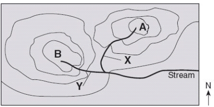
Which direction is the stream flowing?
12
Multiple Choice

The topographic map pictured here shows a river flowing in which direction?
13

14
Multiple Choice

Which side of the landform has a gentle slope?
15
Multiple Choice

Which point, A or B, has a gentle slope?
16

17
Multiple Choice

Which statement best describes the effect of snow on the mountains over many years?
18
Multiple Choice

A student is drawing a topographic map. How would they draw contour lines to demonstrate steepness?
19
Multiple Choice

The following image is of a crater in Arizona. What is likely to happen to the crater over time?
20
Multiple Choice

The image above shows sand dunes in a desert. What process is responsible for changing sand dunes in a desert?
21
Multiple Choice

The image above shows the coastline of Sydney, Australia. What element is going to carry land away from the coast?
Show answer
Auto Play
Slide 1 / 21
SLIDE
Similar Resources on Wayground

17 questions
How we see color PT review
Lesson
•
8th Grade
18 questions
Temperature
Lesson
•
8th Grade
14 questions
Weathering and Erosion
Lesson
•
8th Grade
17 questions
The Sun
Lesson
•
8th Grade
16 questions
Environmental Changes
Lesson
•
7th - 8th Grade
16 questions
HR Diagrams
Lesson
•
8th Grade
15 questions
Natural Selection
Lesson
•
8th Grade
15 questions
Chemical Reactions & the Conservation of Mass
Lesson
•
8th Grade
Popular Resources on Wayground
15 questions
Fractions on a Number Line
Quiz
•
3rd Grade
20 questions
Equivalent Fractions
Quiz
•
3rd Grade
25 questions
Multiplication Facts
Quiz
•
5th Grade
29 questions
Alg. 1 Section 5.1 Coordinate Plane
Quiz
•
9th Grade
22 questions
fractions
Quiz
•
3rd Grade
11 questions
FOREST Effective communication
Lesson
•
KG
20 questions
Main Idea and Details
Quiz
•
5th Grade
20 questions
Context Clues
Quiz
•
6th Grade
Discover more resources for Science
22 questions
Phases of the moon
Quiz
•
8th Grade
10 questions
Exploring the Rock Cycle
Interactive video
•
6th - 8th Grade
20 questions
Waves and Wave Properties
Quiz
•
6th - 8th Grade
10 questions
Understand Ecosystem Roles and Energy Flow
Interactive video
•
6th - 8th Grade
8 questions
Amoeba Sister Asexual vs Sexual Reproduction
Interactive video
•
8th Grade
10 questions
Exploring the Rock Cycle: Types and Formation
Interactive video
•
6th - 8th Grade
20 questions
Heredity Punnett square review
Quiz
•
8th Grade
10 questions
Exploring Weathering, Erosion, and Deposition Processes
Interactive video
•
6th - 10th Grade