
G9 - Topographic maps - Elevation and Slope
Presentation
•
Geography
•
5th - 10th Grade
•
Easy

#Serbianspirit #Serbianspirit
Used 105+ times
FREE Resource
5 Slides • 11 Questions
1
2
3
Open Ended
4

5
Multiple Choice
6
Multiple Choice

What is the elevation of point B?
7
Multiple Choice
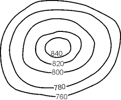
Determine the contour interval:
8
Draw
9
10
Open Ended

Critical thinking: How the slope can affect hikers?
11

12
Multiple Choice
13
Multiple Choice

Which one is the steepest?
14
Multiple Choice
15
Match
16
Open Ended

EXIT TICKET:
1. Explain elevation?
2. Explain slope?
Show answer
Auto Play
Slide 1 / 16
SLIDE
Similar Resources on Wayground

12 questions
The verb "ir"
Lesson
•
5th - 9th Grade
17 questions
Exploring China
Lesson
•
5th - 10th Grade
12 questions
Australia: The Land
Lesson
•
7th - 10th Grade
12 questions
Finding a missing triangle angle
Lesson
•
6th - 9th Grade
11 questions
ESL Halloween Reading Comprehension
Lesson
•
1st - 10th Grade
12 questions
The Outsiders - Chapter 6 - Conflict and Characterization
Lesson
•
6th - 10th Grade
14 questions
Independent Events
Lesson
•
6th - 9th Grade
14 questions
Classifying Triangles
Lesson
•
10th Grade
Popular Resources on Wayground
15 questions
Fractions on a Number Line
Quiz
•
3rd Grade
20 questions
Equivalent Fractions
Quiz
•
3rd Grade
25 questions
Multiplication Facts
Quiz
•
5th Grade
29 questions
Alg. 1 Section 5.1 Coordinate Plane
Quiz
•
9th Grade
22 questions
fractions
Quiz
•
3rd Grade
11 questions
FOREST Effective communication
Lesson
•
KG
20 questions
Main Idea and Details
Quiz
•
5th Grade
20 questions
Context Clues
Quiz
•
6th Grade
Discover more resources for Geography
14 questions
Round One - State Savvy
Quiz
•
7th - 8th Grade
52 questions
2nd Semester Interim Review 35, 36, 37, 38, 39, 40, 50
Quiz
•
7th Grade
14 questions
Awesome Adventures
Quiz
•
8th Grade
14 questions
Round 6: Odd One Out
Quiz
•
7th - 8th Grade
14 questions
Round 5 - History Happens
Quiz
•
7th Grade
22 questions
Northeast States and Capitals
Quiz
•
5th Grade
30 questions
QA #3 Review 2026
Quiz
•
9th Grade
14 questions
Round 6 Odd One Out
Quiz
•
7th Grade