
Reading Map Skills
Presentation
•
Social Studies
•
4th Grade
•
Medium
Standards-aligned

Quincey Marvin
Used 7+ times
FREE Resource
1 Slide • 44 Questions
1
Reading Map Skills

2
Multiple Choice

What is this called?
3
Multiple Choice

What is this symbol called?
4
Multiple Choice
5
Multiple Choice
6
Multiple Select
7
Multiple Select
8
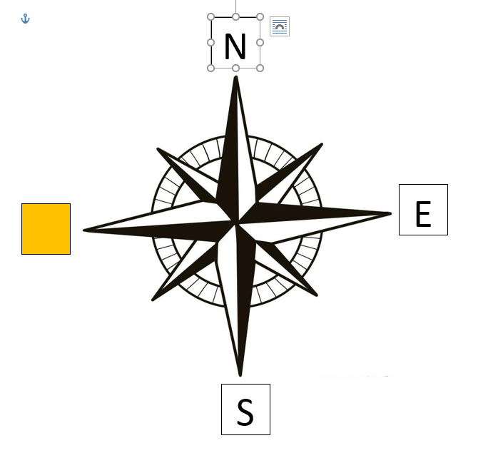
Multiple Choice

Which direction is missing?
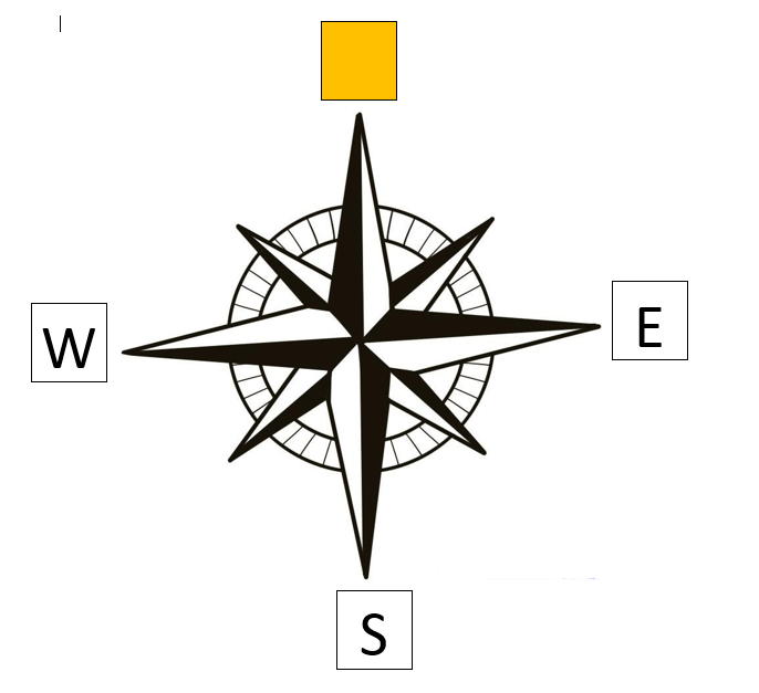
9
Multiple Choice

Which direction is missing?
10
Multiple Choice

Which direction is missing?
11
Multiple Choice

Which direction is missing?
12
Multiple Choice
Which direction is missing?
13
Multiple Choice

Which direction is missing?
14
Multiple Choice

Which direction is missing?
15
Multiple Choice
Which direction is missing?
16
Multiple Choice

What are the names of the three regions of Tennessee?
17
Multiple Choice

A sphere that represents the Earth is called:
18
Multiple Choice

What type of map is shown?
19
Multiple Choice

What type of map is shown?
20
Multiple Choice

What does the scale on a map show?
21
Multiple Choice

The symbols shown are examples of items that would be found on a ______________________ of a map.
22
Multiple Choice
23
Multiple Choice

What ocean is located off the East Coast of America?
24
Multiple Choice

What ocean is to the west of North America?
25
Multiple Choice

What are the lines that run from east to west called?
26
Multiple Choice

What are the lines that go from north to south called?
27
Multiple Choice

What is the area above the equator called?
28
Multiple Choice

What is this map element called?
29
Multiple Choice

What are the states shown in blue known as?
30
Multiple Choice

What U.S. region is shown in red?
31
Multiple Choice

What continent is shown in orange?
32
Multiple Choice

What continent is shown in red?
33
Multiple Choice

What continent is shown in Green?
34
Multiple Choice

What continenet is shown in purple?
35
Multiple Choice

What continent is shown in yellow?
36
Multiple Choice

What is the name of the line that runs horizontally around the middle of a map of the earth?
37
Multiple Choice

What are the lines on the map called that run vertically and meet at the north and south pole?
38
Multiple Choice

What are the lines on a map called that run parallel to the equator
39
Multiple Choice

What does the symbol shown represent on a map?
40
Multiple Choice

When we draw a map in needs to have BOLTS. What does the 'S' stand for?
41
Multiple Choice

When we draw a map in needs to have BOLTS. What does the 'L' stand for?
42
Multiple Choice

When we draw a map in needs to have BOLTS. What does the 'O' stand for?
43
Multiple Choice
44
Multiple Choice

What is a map?
45
Multiple Choice

What is the name of the tool used to find the direction on a map?
Reading Map Skills
Show answer
Auto Play
Slide 1 / 45
SLIDE
Similar Resources on Wayground

41 questions
Civic Affairs & Volunteering
Lesson
•
4th Grade
38 questions
MAY16 Ro-Day-Oh
Lesson
•
4th Grade
42 questions
Civil Rights Lesson
Lesson
•
4th Grade
40 questions
Ancient Egypt
Lesson
•
5th Grade
38 questions
Central America
Lesson
•
5th Grade
37 questions
Martin Luther King JR
Lesson
•
4th Grade
39 questions
Common 4th grade homophones
Lesson
•
4th Grade
41 questions
Problem- Solving
Lesson
•
KG
Popular Resources on Wayground
15 questions
Fractions on a Number Line
Quiz
•
3rd Grade
10 questions
Probability Practice
Quiz
•
4th Grade
15 questions
Probability on Number LIne
Quiz
•
4th Grade
20 questions
Equivalent Fractions
Quiz
•
3rd Grade
25 questions
Multiplication Facts
Quiz
•
5th Grade
22 questions
fractions
Quiz
•
3rd Grade
6 questions
Appropriate Chromebook Usage
Lesson
•
7th Grade
10 questions
Greek Bases tele and phon
Quiz
•
6th - 8th Grade
Discover more resources for Social Studies
26 questions
IA3 Vocabulary Review
Quiz
•
4th Grade
10 questions
Presidents Day
Interactive video
•
1st - 5th Grade
12 questions
Mother of Presidents
Quiz
•
4th Grade
4 questions
BHM Intro
Lesson
•
2nd - 8th Grade
15 questions
Slavery Unit Review
Quiz
•
4th Grade
10 questions
Three Branches Of Government
Quiz
•
4th Grade
11 questions
25-26 Social Studies CBA 4
Quiz
•
1st - 5th Grade
17 questions
Ch. 12 & Ch. 13 Westward Expansion Test
Quiz
•
4th Grade